
This article is written by Bageshwer Singh and Pooja Chand, based on their experiences from walking along River Sindh as part of our Moving Upstream: Sindh Fellowship programme.
Cover photo: Goats and herders (left) crossing the River Sindh. To the right is a bridge broken by floods of 2021

We undertook a walk along the river Sindh in Madhya Pradesh, the stretch of river between Narwar to Badarwas (which are about 180km apart). The path makes a rough North-East to South-West diagonal across Shivpuri district.
Walking through the major changes in the river’s ‘life’ – we started from the Narwar-Magroni bridge where the river is just a shallow stream that one can easily walk across, immediately followed by the reservoir of the Mohini Sagar Dam a few kms upstream. Further upstream, between Mohini Sagar and Atal Sagar Dams, there is a 5-6 km stretch of a slow moving, deep river before we arrive at the Mandikhera-Atal Sagar Dam.
Moving upstream through the massive turns along the dam, navigating through thick forests, an extant village and ghosts of submerged villages, we reach the end of the dam’s backwaters about 25-30km upstream. Here, the river gradually becomes its own self as we move upstream – through the tropical dry deciduous forests in the plateaus and riverine Acacia scrubs, to settlements in plains with acres of wheat, mustard, pea and lentil fields.
The first sight of the river was interesting. We were about to reach Narwar from Gwalior and the bus stopped midway on the bridge over the Sindh. We assumed some technical problem with the bus, which did seem quite rusty and was overcrowded as well. All passengers started deboarding the bus and we realized the reason for stoppage only once we deboarded.
It was the Magroni-Narwar Bridge, Magroni being the village on the left bank and Narwar on the right bank. No vehicle crosses the bridge without pausing on the bridge and paying respect to the river. Only after the ritual of breaking a coconut and lighting a lamp does one move forward. Locals told us that it is a bad omen if the Sindh is not worshipped. From Narwar, we started walking.

Changing landscape and biodiversity
We moved upstream, southwards through several forest types, meeting interesting species of flora and fauna. From a pure dhok forest to the region of dry deciduous broadleaf forests.
Starting along the Mohini Sagar dam, we walked through the scrub of heavily browsed Dhok (Anogeissus pendula). Dhok shows an amazing adaptation feature here – if browsed when young, the plant grows into a shrub, otherwise developing into a medium sized tree. We could see the shrubs along the reservoir neatly browsed by goats, reminding us of properly manicured tea gardens. On the hilltop, we could see the Dhok trees as high as 10-15 metres. Goats are doing a rather excellent job as gardeners there, keeping the shrubs in shape.

Further, along the river, it’s all soil and sand with rocks in between. We could see the unidirectional bent of all the riverine trees – an effect of past floods, trees almost uprooted, roots holding on to the boulders.
Walking towards Madikheda dam, the whole landscape changes eventually. Since the riverine forests have disappeared with the dam, a typical dry deciduous forest has emerged with outliers such as Gurjan (Lannea coromandelica), Salayyia (Boswellia serrata), Semra (Bombax ceiba) and Kulu (Sterculia urens), with their distinctive barks and branching. The forest stretches for at least 60-70km along the river with the hills on the left bank being the part of Madhav National Park, and just a few villages on the right bank.
We were welcomed by a riverine forest once we crossed Amola bridge and left the dam reservoir behind. Along the flowing river was a more thorny forest dominated by species of Acacia. Katjumni (Syzygium salicifolium) was found in the streams, small river islands covered with thickets of Katjumni.

Moving further upstream, the river bed was wider with big boulders and rocks dominating the river bed, creating big pools of water in between and constantly changing direction of the stream. Further upstream, it is a slow-moving river with a level sandy bed and agricultural fields on both the banks.
In the first few days we had a checklist of over 70 bird species as we walked around the reservoir, noticing the birds and butterflies and bees feeding on wild flowers. Interestingly, there were almost no waterbird species around the dam. Once we crossed the reservoirs, the backwaters with the snags and partially submerged villages provided an excellent habitat for birds – with our checklists now showing upto 60 bird species recorded in a single day.
The snags (Dead trees) were more alive than the live trees of the forest for waterbirds, providing a space for perching, nesting and also acting as reservoirs of food, a lookout for fish hunting. Snags clearly signified their importance as a habitat for waterbird species.
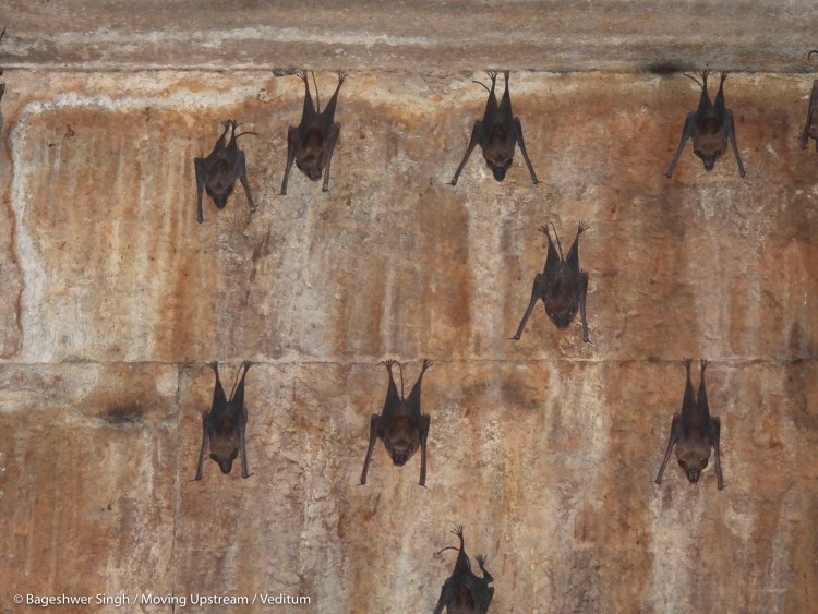


Madhya Pradesh is popularly known for its historical buildings, and these old buildings are also perfect roosting sites for bats. During our walk, we came across two species of bats – Tomb bat and Mouse tailed bats – roosting on walls and the domes in a very large number at Surwaya ki Garhi, an old archaeological site.
Deep ravines and gullies forming their own microhabitats, pools in the stream beds make small ecosystems with tadpoles and skittering frogs and smaller fishes, Muggers (crocodiles) found basking on rocks or sandy slopes, and Fig species with its large supportive roots often found hanging on to cliffs along the river.
Sindh – a dynamically changing river with dynamically changing landscapes.

People and nature
One of the ideas most inconceivable for us was to try and imagine a life after getting displaced. What happens once someone’s house and village is drowned in a dam? The Atal Sagar dam was completed recently (2008), and 9 villages were displaced with “compensation” in the early 2000s to different locations along Shivpuri-Jhansi highway.
A brief meeting with Sahariya adivasis at Chhatpur Colony Punarwas Phase 2, talking about their life before the dam:
It was late morning and people were almost ready to leave for their day’s work. Our questions made them nostalgic about those days. “Yha kachu nahi hai, Sarkar ne aakar patak dia”. Birenad Adivasi says, “Pehle ghar ke paas se Ganga maiya behti thi, ab Ganga maiya hmare ghar me birajmaan hai.”
They recalled life when the river was in their front yard, forests all around where they could take their livestock for grazing and collect forest produce, and farm their land for a self-sufficient life. When the river met their water needs, they did not have to rely on just one hand pump in the village. The compensation for their land was not enough for them to buy more expensive farm lands near the highway. They now resort to manual labour and daily wage jobs to make a living.
Beyond this, how do we compensate for the ecological loss?

In the villages further upstream like Saknaur and Badhota, past the hills and forests in the large fertile plains, we came across flocks of Blackbucks moving around, resting and grazing in the agricultural fields, with locals working simultaneously, indifferent to the antelopes. This was a region where wildlife could move around freely, unlike villages downstream where fields were fenced by thorny shrubs and branches to keep away animals.
With the expansion of agriculture in the region over decades, the blackbuck habitat has become limited, which has eventually led them to forage in the fields. Although another reason for the indifference / inaction is the helplessness of the local communities given the protection status of Blackbuck (under the Widlife Protection Act of 1972).

Our first sighting of a Mugger was at village Karmai Kalan. The actual village is submerged in the dam, and few remains of snags and electricity poles and roofs are visible in water, along with two partially submerged wells. One well is used by villagers who are still around to meet their water needs and the other one is a basking site for Muggers. Children were excited to show us the shared space with the Mugger. Further upstream, where the river is still ‘untamed’, Muggers were a regular sight.
Our hosts in village Bichi recalled an incident when a Leopard came for their dog the previous week, but ran away once the villagers woke up to the ruckus. Balraj Kaur was very attached to her pet, but acknowledged that while living in the forest, meeting its other residents is quite expected, and if one is aware, conflict could be avoided. She was also sure of the presence of lions and tigers in the forest.
At village Kenwaha, Yashwant Gurjar, our host, showed us around all the local trees and shrubs and was excited to see these trees featured in Pradip Krishen’s ‘Jungle Trees of Central India’. He could not read, but was able to very well navigate the trees from the book. Showing us some tree locations the next morning, he recalled the sweet smell of flowers of Sirs (Albizia procera) from the forests in the rain.
Dam dammed the power?

Madikheda dam was built with promises of development and employment – yet none of the villages along the Madikheda dam have a 24 hour power supply. Time slots: 8am-12pm, 12am-8am, 6pm-12am, were pre-announced for power cuts. While the timings for the power cuts are fixed, the supply remains erratic.
Karmai Kalan, the village at the edge of the reservoir where we saw a crocodile with the kids, did not have a power connection at all (Interestingly, this village does not exist in current records, and we navigated our way using GPS assistance). Only once we met the flowing river again upstream, that a 24 hour power supply was seen.
We saw toilets built in all the homes under the Swachh Bharat Mission (SBM), but often they were without a water connection. Water has to be fetched from a very far located handpump, and one has to line up in a row to get the chance to fill their vessel. Whole villages had limited handpumps. Therefore, many villagers still prefered open defecation even after having proper toilets in their houses.

Beyond sanitation and electricity, in the absence of working Primary Health Centres (PHCs) people have to travel many miles to reach nearby towns like Shivpuri, Narwar, Karera etc for health facilities. Even the hotline number 108 for ambulances in case of emergency works only if the network permits.
Community structure, castes and tribes
Different communities reside in these villages, and one of the first questions we were asked when entering any village was, ‘Aap kon jaati ho?’ (Which caste do you belong to?). Caste determines a lot in the villages from socio-economic status, occupation, culture, dominance etc., and including school attendance & education. Adivasi, being ‘casteless’, people were indifferent to them.
The villages were also physically structured in that way. For instance, in case of village Udwaha, the only extant village among others displaced by the dam:
Entering the village, there is an orchard of Ber (Ziziphus mauritiana), a colony of adivasis, then a fenced road followed by another adivasi colony, their common hand pump. A village shop owned by Thakur-Rajput in the centre of the village, where most of the pukka houses are present, along with a school and Anganwadi (child care centre). Further along the path are dwellings of Gadariya and Baghels with their livestock. Kushwaha owns the other end of the village, with big spacious courtyards for their tractors and trailers. Each community had their own hand pump.
There seemed no apparent conflict but a well understood and obvious division of land and labour. Forest resources are divided too – only the Adivasis collect the gum/resin from Salayia & Chhela trees, Gurjars use it for grazing, and firewood collection is done by everyone. Almost all the households have received an LPG cylinder but LPG cooked food causes them digestion issues. Refilling a cylinder is also a tough job, the nearest refilling centres in cities are 20-25km away while the firewood is available in the neighbourhood.
The houses were quite vibrant and colourful, mostly painted with a coat of clayey soil from the forest. Most of the Sahariya houses for example had floral patterns made on their walls. Neem trees were a common feature of their courtyards, with a sitting space along the tree, bordered with white soil, collected from the forest.

The adivasis have been in such perpetual cultural suppression that the concept of going to school seemingly didn’t make any sense to them. A young boy replied “Adiwasi ka bacha school jata h kya, hum mehnat karte hain” when we asked whether he goes to school or not. None of the children study since it will reduce the productive working hours, and schools barely open anyway.
Teachers come only once or twice a month, and rest of the time schools remain closed. Since there is no vision or example that has convinced them that formal education could be beneficial to them, our inputs or insistence wasn’t very convincing either. They undertake all sorts of daily wage labour and barely earn enough to make ends meet.
“Shilp Haat, Udwaha” was constructed in 2014 to showcase tribal and village handicraft, as an idea to generate employment opportunities out of craft. But it didn’t make sense at all, that the community which is barely able to make ends meet could create a market in the only village in a large stretch of forest with no networks. Currently the shilp haat is a multifunctional space as a cattle shed and a place for Open Defecation.

Our appearance and people’s perceptions
Pooja writes: Having a smiling face, short height, that too in a patriarchal society, people don’t take you seriously. They either looked at me with pity and often asked Bageshwer, “why have you brought this 12 year old girl?”, “if it’s your ‘searching’, you should not have brought her in this difficult terrain.” They were often confused whether I’m a girl or a boy, asking me “tum ‘मोड़ा’ (boy) hai ki ‘मोड़ी’ (girl)?”. They mostly practised “Men-to-Men talk”. I sometimes felt left out of the conversation.
In the villages we visited in that region, there is the custom of elders touching the feet of younger girls – this was quite a cultural shock for us. For instance, our host at Nanakpur, near Narwar, an elderly lady who was also the head of the family, touched Pooja’s feet, her son-in-law’s feet and her daughter’s feet. In Anandpur it happened again – our host touched Pooja’s feet before bidding us farewell next morning.
Between 1950s and 60s, post independence, when most people in Punjab and Haryana (then Punjab) were displaced, few families from that region bought some land along Sindh river, and gradually settled there with their farms. We met many such families, and with Bageshwer being from Punjab, we got huge support from them during our journey. They are one of the largest landholders in the region, farm the most fertile lands, and employ many adivasis on their farms.
As we walked with a camera and binoculars in hand, we had to explain to the people about our ‘research’ or the purpose of our walk. ‘Survey’ was the most common word people could relate to, or one of the villagers would guide into their village, telling everyone as, ‘यह सर्चिंग कर रहे हैं, नद्दी-नद्दी’ (They are looking for something along the river). Learning a few words such as ‘डांग’ for the forest, and ‘डंगराते हुए’ as walking on foot. ‘आहो’ or ‘और का’ as yes/affirmation. Adivasis or other marginalized groups looked at us with suspicion, taking us as government officials, who might take their land for some other developmental work.
Children, adults, everyone alike were most surprised to look through binoculars and we got many responses as to their perceived use of it. Ranging from a device to monitor their cattle grazing in forests, to checking the harvest and intrusion in their fields to one of the responses being, how easy it would have been, if you could actually shoot through it, and would have made hunting easier. Someone was curious if we could look at buried treasure through this device. We often went birding with the locals, many children accompanying us to look at waterbirds. They’d tell us the habits of those birds, and we shared with them names of these birds (in our language) and their preferred habitats.

Floods of 2021
It was a trauma in almost all of the villages we’d visited, and people were still trying to recover from the losses. From lost vehicles, prized possessions, crops, livestock to even loss of human lives in a few regions. We heard stories of how the privileged people either went to Shivpuri, while some decided to volunteer tirelessly to rescue those who were stuck – like our host in Narwar. An 18-year-old boy, Harsh, along with the locals, worked to rescue faculty members stuck in the Jawahar Navodaya Vidyalaya at Magroni, navigating through dangerous waters. The floods were so fierce that bridges were broken both downstream and upstream of dams.
You can read more about the floods in this article – Sindh: Across its banks and beyond – by another group of Moving Upstream fellows, Aishani and Rahul.

In Badhota, a pregnant woman in a boat was trying to reach a safe place for giving birth, but the currents were very strong. Somehow people managed to rescue her using ropes and whatever else they could find, having to dive deep in turbulent waters to save her. In Lilwara, with the houses drowned in water, people camped uphill and had to go without food for 2-3 days. Adivasis, having their houses closest to the river, were most affected. Higher castes’ having houses built on comparatively safer lands. The division of land works against the socially marginalised.

Dams and people and forests – finding the Sindh
We have our own perceptions for how life around the river is. Being naturalists, we both saw life from an ecological lens. The biodiversity around the river, microhabitats, changing ecosystems and forests. Almost no one in any of the villages we visited could read and write. Even at present, the condition of schools is deplorable. Proper healthcare and sanitation still seem like a distant dream. Yet, the knowledge the inhabitants of these forests possess, is invaluable. Quite often, while walking through forests, we were accompanied by locals who would show us the way. They could name all the trees and shrubs, often indicating the identifiers.
An interesting contrast presents itself in how the forests have defined the lives of Adivasis – collecting and selling forest produce. And how development has defined their livelihoods – one of the common forest produce from the region is the gum of Salayia (Indian Frankincense), yet none of the inhabitants could tell the use of it. All they knew was that it sells between 150-300 rupees per kg.
The dam displaced 9 villages, mostly tribal settlements. Could the knowledge have also gotten displaced, that which was linked to that particular landscape? The plant community, the affiliations with the river, the forest produce? How can that knowledge of a free river, of the forest and the intangible wealth that existed over the centuries be compensated?
We are not sure if anything of what we do will make sense to the inhabitants we met, or we would ever be able to see things from their perspective to know them better. Yet, this walk was a small attempt to understand life around the river and come up with stories from these lesser known river stretches which never reach the headlines.
While we looked at the experiences from a broader perspective, reimagining the vastness, connecting the rivers, dams, people and biodiversity, a river emerged out of it and connecting these dots, we found an Overstory. More will be followed with detailed observations and outlooks. We are grateful to Veditum for this opportunity.

Pooja Chand is a wildlife researcher at Ashoka University and is keen on understanding how plants and animals interact with each other. When she is not studying plants and animals, she engages herself in dance, explorations, and a lot of coffee.
Bageshwer Singh is currently working with a youth organization PAHAL, based in Jalandhar, Punjab and leading a project on Ecological Assessment of Kanjli Wetland with The Rufford Foundation, UK. Interested in identifying the plants he sees around, and understanding their interactions with other wild-life. He wonders and wanders quite often.
Bageshwer Singh and Pooja Chand are fellows who walked along River Sindh for 12 days. This exercise is part of our Moving Upstream Fellowship program that we host in collaboration with Out of Eden Walk. To read more about our Moving Upstream project, click here.
Reach Bageshwer at bageshwersingh30@gmail.com and Pooja at poojachand2408@gmail.com. If you’d like to commission stories from this walk, please write to the authors or email us at asid@veditum.org
This piece can be re-published (CC BY-NC-SA) with a line mentioning ‘This was originally published on Veditum’ and a link back to this page. In case of re-publishing, please alert asid@veditum.org
If you find our work to be of value, consider supporting our work through a donation. Donations and grants make our work possible.
Click here to donate: www.veditum.org/donate
Very good efforts to know which is not common for common persons and give knowledge how our Indians lived so tough life. We can’t imagine this type of life
Thanks for organising this type of walk
Thanks for those who really walked
Thanks for sharing your outcome
Blessings all of you and the people who lived so tough life
Thanks For Sharing The Informative Blog.